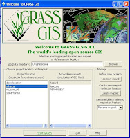
 GrassGIS is created following the many of open source project is created. I mean, the GUI is designed for bunch of folks working at the same project. On the other side, the popular proprietary GIS tools is created for single user. Same as a proprietary operating system and so forth.
So in the GrassGIS starting window, you see my project namely Jakarta with several bunch of maps (and calculations, for later works) which GrassGIS call it mapsets. This is because I work the project by myself.
In a multi user environment, the mapsets may refer to user1, etc. Perhaps, user1 only have task to do certain calculation based on PERMANENT mapsets.
This way, the raw data and the work is easily seen. Not by intepreting the possible filename that is 'invited' in a "catalog".
I think that the start.
Strive!
No comments:
Post a Comment